Home / Estuary Habitat
The Humber Estuary is internationally important for wildlife; its intertidal areas provide a complex and highly productive ecosystem that supports a wide range of habitats and species. It is recognised as one of the 10 most important estuaries in Europe for birds. Over 20% of England’s surface water drains into its catchment, making it the largest single input of freshwater into the North Sea from England. It supports internationally important populations of seven species considered at risk of extinction, rare or vulnerable, including Hen Harrier, Golden Plover, and Bar-tailed Godwit. The estuary provides around 150,000 waterfowl with safe feeding and roosting grounds over the winter, and during spring and autumn migrations. It is also an important migration route for migratory fish species such as Lamprey. In summer, it supports several important breeding populations of scarce or declining species such as Bittern, Marsh Harrier, and Avocet. Over 400,000 people either live or work within the Humber floodplain and 12 million in the wider catchment.
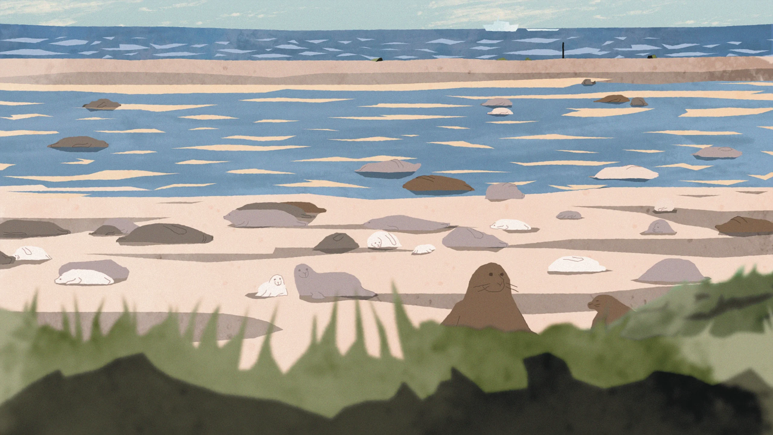
Tidal inundation at different scales creates an assemblage of unique habitats that provide a variety of shelters and food sources, from mud worms and molluscs in the mudflats, to samphire in the saltmarshes. A complex of beaches adjacent to coastal lagoons supports our only population of breeding Little Tern. Large scale reclamation of land adjacent to the estuary took place from the 17th Century to the beginning of the 20th Century. This resulted in large fields bounded by ditches, which form high-quality arable cropping land, but are susceptible to tidal flooding. The many ditches form important networks linking the inland habitats with the estuary. Land reclamation has also created areas which support waders and wildfowl that use intertidal estuary habitats. It is critical that functionally linked land across the area is recognised and enhanced to support the species associated with designated sites of the Humber. Creation of new areas of intertidal habitat through managed realignment adjacent to the estuary can provide multiple co-benefits, including carbon storage within the extensive estuarine sediments and natural flood management to protect against tidal surges and rising sea levels, which are intensified by the increasing frequency of extreme weather events due to climate change.

Lamprey, Salmon, Brown Trout, Smelt, Shore Crab, Bass, Herring, Eel, Golden Plover, Black-tailed Godwit, Bar-tailed Godwit, Ringed Plover, Lapwing, Wigeon, Teal, Mallard, Shelduck, Knot, Oystercatcher, Avocet, Little Tern, Sanderling, Dunlin, Ruff, Curlew, Redshank, Turnstone, Bittern, Marsh Harrier, Hen Harrier, rare aquatic beetles, and Sea Aster Mining Bee.
Reedbed, mudflats, saltmarsh, wet grassland, lagoons, drains and ditches, and sand dunes.
Flood mitigation and climate change adaptation.

Protecting and enhancing biodiversity is an important goal for the Environment Agency as part of the Outstrays to Skeffling Managed Realignment Scheme, where 170 ha of intertidal habitat (saltmarsh and mudflats) has been created along with 87 ha of supporting freshwater habitat. These protect and enhance biodiversity within the Humber Estuary by replacing habitat losses resulting from the Environment Agency’s work to reduce the impacts of flooding.
Benefits can already be seen from habitat creation, including sightings of rare and endangered bird species in both the terrestrial and intertidal habitat areas. The Environment Agency are also safeguarding the SSSI site at Haverfield which is important for butterflies, priority species such as Sea Aster Mining Bee, and other invertebrates. Trees and hedgerows have also been planted across the site to provide corridors for wildlife.
The Environment Agency’s mission statement is to protect and improve the environment. Around the estuary, the Humber 2100+ partnership is working to develop a long-term approach to manage the consequences of sea level rise and tidal flooding. The needs of the natural environment will be embedded into any future approach for managing tidal risk, supporting nature’s ability to adapt, and in turn enhancing the resilience of the wider area.
Loss of habitat is a major threat to wildlife populations in the estuary. The Environment Agency’s ambition is for the new habitats as part of the Outstrays to Skeffling Managed Realignment Scheme to contribute to the mosaic of sites around the estuary, providing space for nature to thrive in the future and giving people better access to nature and opportunities to learn about what makes the estuary a special place.
The project is a partnership between the Environment Agency and Associated British Ports.
Brough South Airfield is an example of development and nature co-existing to produce positive results for wildlife. The disused airfield site is nestled within the Brough South development on the banks of the Humber Estuary, a large mixed-use development creating hundreds of homes, a school, care home, retail units, and associated amenities for people in the area. The Brough South Consortium has led on the implementation of a range of ecological enhancements around the development to provide a valuable home for wildlife.
The airfield is designated as a Local Wildlife Site due to its botanical interest but is also an example of functionally linked land used for feeding, roosting, and nesting bird species linked to the Humber Estuary SAC and SPA. Although the land does not have the same level of protection as areas within the Humber, it plays a critical role in the survival of the species who do utilise the protected areas. The site is dominated by wet grassland and features a small quantity of reedbed, lagoons, and neutral grassland which is managed using a hay cut. Management of this part of the site is overseen by the Brough South Ecological Management Group, which includes representatives of the Yorkshire Wildlife Trust, the RSPB, Natural England, and ERYC.
An early assessment of the site concluded Brough South could play an important role in supporting populations of waders, in particular Curlew, Lapwing, and Golden Plover. 36 ha of land adjacent to the Humber has been dedicated as a nature reserve and a number of ecological enhancements have been made to provide the necessary habit these species require, including:
Studies conducted by the RSPB have shown that the area is having a beneficial effect on biodiversity by attracting additional wildlife and new species to the area, including Eurasian Curlew and Marsh Harrier. Residents and visitors to the area can learn about the conservation work as local wildlife via information boards erected around the site.
